
Here are all the confirmed North Texas tornadoes, their EF rating and path
The final details and information will not be known for at least several days.
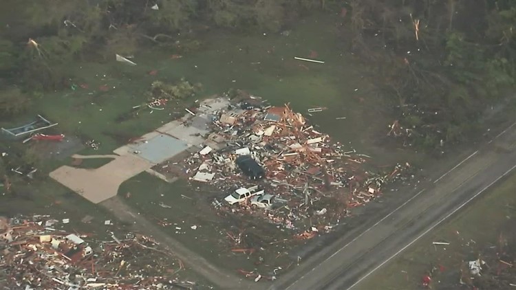
DALLAS — Severe weather led to a several tornadoes in the North Texas region on Friday. As of Monday morning, we now know of at least four confirmed tornadoes, according to the National Weather Service.
Storm surveys are still ongoing to determine the exact strength, path length, number of tornadoes, etc. The final details and information will not be known for at least several days.
So far, the only severe weather reported in the Dallas-Fort Worth area was wind damage and a few instances of quarter size hail.
Here’s where they happened, when and how the Weather Service has categorized them:
- Time: 4:19-4:46 p.m.
- EF Rating: EF-3
- Peak winds: 160 mph
- Maximum width: 3/4 of a mile
- Path length: 22 miles
- Time: 5:15-5:19 p.m.
- EF Rating: EF-1
- Peak winds: 100 mph
- Maximum width: TBD
- Path length: TBD
Hopkins County (SW of Sulphur Springs)
- Time: 5:15-5:19 p.m.
- EF Rating: EF-2
- Peak winds: 120 mph
- Maximum width: TBD
- Path length: TBD
Athens (Henderson County)
- Time 5:35-5:58 p.m.
- EF Rating: EF-2
- Peak winds: 115 mph
- Maximum width: 150 yards
- Path length 15 miles
The severe weather cleared out of North Texas by Friday evening. Dallas-Fort Worth missed the worst of it, though strong winds and heavy rain blew through the area before the storms intensified to the east of the Metroplex.
Clouds and rain chances returned to North Texas on Monday but severe storms were unlikely. Election Day on Tuesday was expected to be dry and breezy with highs around 80 degrees.
Another cold front later this week could bring much cooler weather back to North Texas, with highs in the 50s expected this weekend.
Dallas Press News – Latest News:
Dallas Local News || Fort Worth Local News | Texas State News || Crime and Safety News || National news || Business News || Health News
texasstandard.news contributed to this report.


