
Evacuation orders and warnings issued for more areas in Santa Cruz County, emergency shelters open
SANTA CRUZ COUNTY, CA (KION-TV) – March update. 10, 2023 at 6:24 am— The Santa Cruz County Sheriff’s Office issued additional evacuation orders and warnings for several areas of the county ahead of potential flooding this weekend.
Evacuation is carried out in the following areas ORDERS until further notice:
- Zone WTS-E018-A And WTS-E017-A: Areas northeast of Main Street along Bridge Street to the end of Franich Park are under evacuation orders in Watsonville. This includes Watsonville High School and City Plaza Park.
- Zone FEL-E008 or the Felton Grove area.
- Zone FEL-E012 or the area north of Highway 9, south of Beth Drive, east of Highway 9, and west of Beth Drive
- Zone CRZ-E081 or the Paradise Park area.
- Zone CTL-E014-B which includes north of Soquel Drive, south of Paper Mill Street, east and west of Porter Street.
- Zone CTL-E015-B which includes north of Soquel Drive, south of Main Street, east of Paper Mill Street, and west of Main Street.
- Zone CTL-E018-A which includes North of Wharf Road, Cabrillo Highway, South of Porter Street, Soquel Drive, East of Porter Street, Wharf Road, West of Main Street.
- Zones PAJ-E015-B And PAJ-E024-B or the area north and south of Liberty Boulevard from Earth Lane and Compton Terrance.
- Zone PAJ-E026 which includes north of Wagner Avenue, south of Minto Road, Holohan Road and east of Atkinson Lane, Cottage Road, Marigold Avenue and west of East Lake Avenue.
- Zone PAJ-E027-B which includes north of College Road, Salsipuedes-Pajaro Bike Path, Lakeview Road, south of Anderson Drive, east of East Lake Avenue, Salsipuedes-Pajaro Bike Path, and west of Plum Hill Drive, Lakeview Road.
- Zone PAGE-E028 which includes north of Village Way, Lakeview Road, Riverside Road, south of Salsipuedes-Pajaro bike path, Lakeview Road, east of Condit Lane, East Lake Avenue, Bridge Street and west of Lakeview Road, Riverside Road.
- Zone WTS-E005-B which includes north and south of Compton Terrace, east of Quick Stop and Compton Terrace, and west of Airport Boulevard and Compton Terrace.
- Zone WTS-E005-C which includes north of Paharo Court, south of Airport Boulevard, east of Paharo Court, Airport Boulevard, and west of Green Valley Road, Airport Boulevard.
- Zone WTS-E006-B which includes north of Marigold Avenue, south of Holohan Road, east of Green Valley Road, and west of Packard Lane, Atkinson Lane.
The Santa Cruz County Sheriff’s Office provided multiple zone shelters Friday morning as both lanes of block 3600 on North Main Street in Soquel were washed out. Deputies advise drivers not to drive through the blocked road, as this can lead to injuries. The areas involved in shelter in place include
CTL-E005- north of Timber View Road, Lagunita Drive, Ginger Lane, south of Hacienda Lane, Glen Haven Ridge, east of Soquel San Jose Road and west of Glen Haven Road.
CTL-E010– North of Fairway Drive, south of Glen Haven Road, east of Soquel San Jose Road and west of Eight Verse Trail Loop.
Evacuation is carried out in the following areas WARNINGS until further notice:
- Zone WTS-E019-A or the area south of East Riverside Drive and north of the Pajaro River, east of Main Street.
- Zones CTL-E027-A which includes north of the Venetian Hotel, south of Cliff Drive, east of Capitola Pier, Wharf Road, and west of Esplanade.
- Zone CTL-E028-A which includes north of Riverview Avenue, south of Riverview Avenue, Riverview Drive, east of Riverview Avenue, Riverview Drive, and west of Riverview Avenue.
- Zone CTL-E029-B which includes north of Capitola Beach, south of Stockton Avenue, Capitola Avenue, east of Esplanade, Riverview Avenue, and west of Britannia Arms.
- Zone CTL-E051-B which includes north of Stephen Road, Esplanade, south of Spreckels Drive, Forest Drive, east of Creek Drive, and west of Treasure Island Avenue.
Ramsay Park on Main Street will serve as an information center and reunion site, and will also offer snacks and water.
Overnight shelters are located at the Watsonville Veterans Memorial Building (opens at 4:00 pm) at 215 E. Beach Street, Watsonville and at the Cabrillo College Gym (opens at 7:00 pm) at 6500 Soquel Drive, Aptos.
“Inhabitants of low-lying areas must be prepared to evacuate and relocate to higher ground,” the district warns. “If possible, consider moving before the weather system launches.”
To view the latest warnings, click here.
Storm shelters will open in Santa Cruz County.
One will be located at the Watsonville Veterans Memorial Building at 215 E. Beach Street, Watsonville at 4:00 pm.
Another will open at Cabrillo College Grammar School at 6500 Soquel Drive, Aptos at 7:00 pm.
There will also be a daylight evacuation facility at the Scotts Valley Community Center, 370 Kings Village Rd, Scotts Valley.
The shelters will provide people with a place to sleep, eat, and receive supplies and support services. For more information about the shelter click here.
School closures on Friday:
- Watsonville High School
- Watsonville Children’s Center
- Renaissance High School
- Paharo Middle School
- Ann Soldo Elementary School
- Alliance Charter
- Bradley Elementary School
- Watsonville Charter School of the Arts
- Lakeview High School
- Paharo Middle School
- Adult education in district government
- Pacific Coast Charter School
- Watsonville Children’s Center
These schools will continue to offer classes online.
“To avoid interrupting student learning, students from closed sites will be able to access assignments through Google Classroom,” the Paharo Valley Unified School District said. “Teachers and administrators will assign work to students by 9:30 a.m., and staff will check on them throughout the day.”
ORIGINAL STORY
The city of Watsonville has issued evacuation warnings for several areas within the city limits due to potential flooding this weekend.
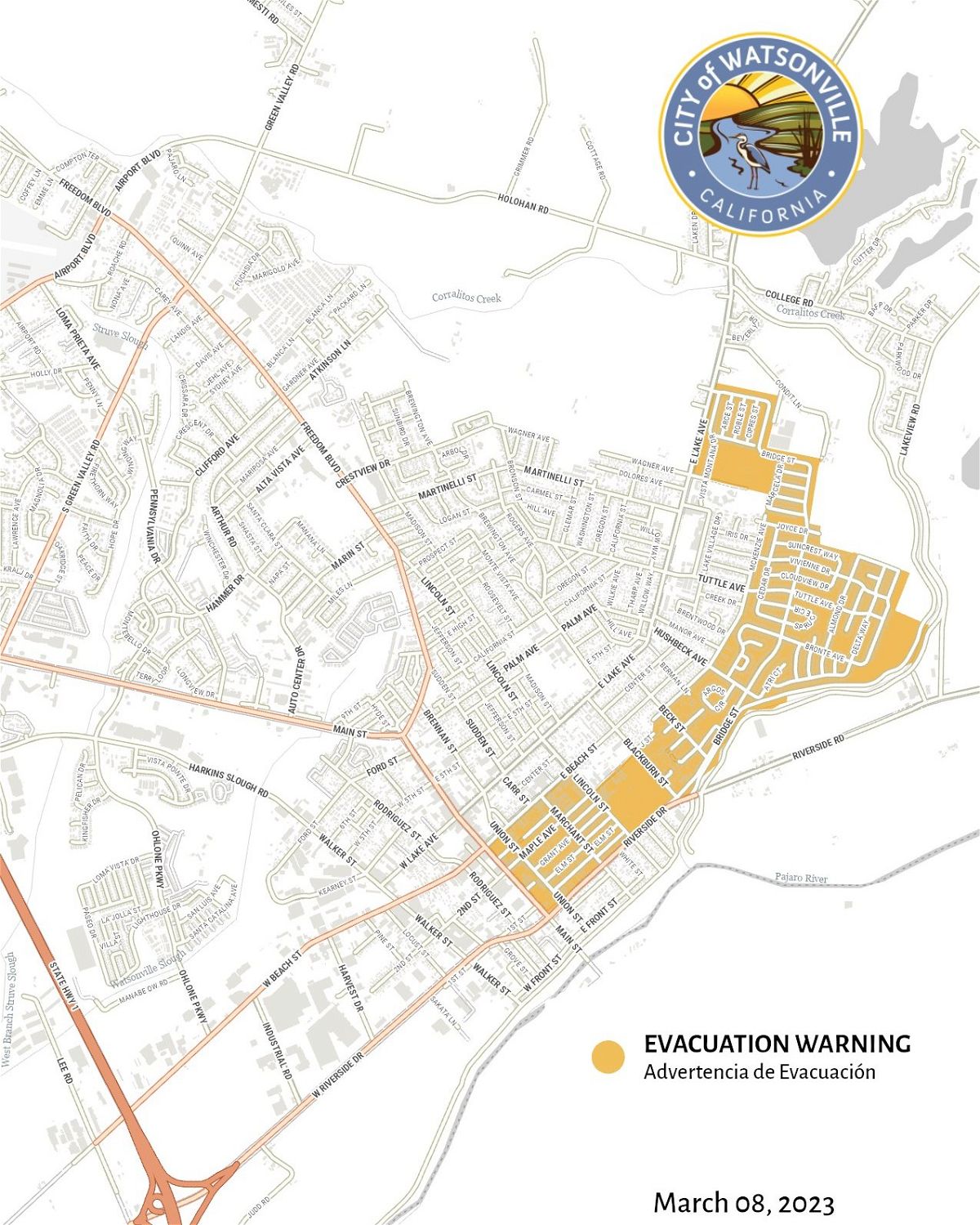
The area shaded in yellow above is under an evacuation alert as the National Weather Service predicts heavy rain from late Thursday through Friday.
People living in evacuation warning zones must be prepared to protect their property and be prepared to leave the area if conditions change. Anyone affected by recent floods should consider themselves at risk of future floods, the city warns.
“Keep kits” should be prepared and families should have plans for their children, pets, essentials and medicines. The city also reminds people of the need to clean up storm drains.
“Emergency notifications will come through CodeRED, a phone alert system,” the city said. “Residents must register for information at www.scr911.org or text SCR911 to 99411. You can also be notified by downloading the Watsonville Police Department mobile app or the CodeRED app.”
The Emergency Operations Center was also activated ahead of expected storms.
Dallas Press News – Latest News:
Dallas Local News || Fort Worth Local News | Texas State News || Crime and Safety News || National news || Business News || Health News


